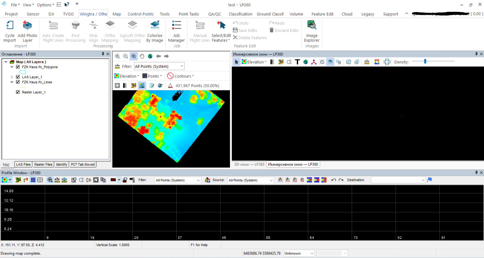
Description
LP360 2025: A Powerful LiDAR Data Processing Solution for Surveying, Mapping, and Geospatial Workflows
LP360 Software Review Summary
LP360 is a powerful LiDAR data processing and point cloud analysis solution designed for professionals who need accurate, efficient, and practical tools for working with 3D geospatial data. From surveying and topographic mapping to corridor design, forestry, infrastructure inspection, and drone-based LiDAR projects, LP360 helps transform large point cloud datasets into useful information without forcing users through unnecessarily complicated workflows.
What makes LP360 particularly valuable is its practical approach to LiDAR processing. Instead of treating point cloud data as something that must be exported through multiple disconnected applications, LP360 provides a structured environment for classification, visualization, editing, analysis, and deliverable creation. Users can work with LiDAR data more efficiently while maintaining control over accuracy and project quality.
For surveyors, GIS professionals, civil engineers, drone mapping specialists, and geospatial teams, LP360 can be a strong choice when reliable LiDAR processing, point cloud classification, terrain analysis, and production workflows are essential.
Introduction
LiDAR technology has changed the way professionals collect and analyze spatial information. Modern airborne, mobile, and drone-based LiDAR systems can capture millions or even billions of points in a relatively short time. However, collecting LiDAR data is only one part of the process. The real challenge often begins afterward.
Raw point cloud data must be organized, cleaned, classified, inspected, analyzed, and converted into useful products. This is where LP360 becomes an important tool in the geospatial workflow.
LP360 is designed to help users manage and process LiDAR data through a professional point cloud environment. Rather than simply displaying a 3D dataset, the software provides tools for working with the data at multiple stages of a project. Users can inspect point clouds, improve classifications, generate terrain information, analyze surfaces, and prepare results for mapping or engineering applications.
A common experience among new LiDAR users is opening a large point cloud and immediately feeling overwhelmed by the amount of information on screen. LP360 addresses this challenge by offering tools that help users organize and interpret complex datasets more effectively.
Whether the project involves a small drone survey or a large-scale mapping operation, the software is built around the idea that LiDAR data should become easier to understand and more useful during every stage of processing.
Key Features of LP360
Advanced LiDAR Point Cloud Processing
At the center of LP360 is its ability to work with LiDAR point cloud data. Users can load, visualize, inspect, and process large datasets while maintaining access to detailed information about individual points and their classifications.
This is particularly important for projects where accuracy matters. A point cloud is not simply a collection of dots. Each point can contain elevation, intensity, classification, return information, and other attributes. LP360 provides tools that help users make sense of these datasets.
Point Cloud Classification
Point cloud classification is one of the most important steps in LiDAR processing. Ground, vegetation, buildings, water, power infrastructure, and other features may need to be separated for further analysis.
LP360 includes tools that support classification workflows and help users review the quality of existing classifications. Automated processing can improve efficiency, while manual editing tools allow professionals to correct areas that require closer attention.
This combination is valuable in real-world projects because automated classification is not always perfect. A professional workflow usually requires both automated processing and human quality control.
3D Visualization
Working with LiDAR data becomes much easier when users can view the dataset from different perspectives. LP360 provides a 3D environment for examining terrain, structures, vegetation, and other features.
Users can rotate, zoom, inspect, and analyze point clouds to identify problems that may not be obvious in a traditional 2D map.
For example, a survey technician may notice an unusual elevation pattern in a profile view and then investigate the same area in 3D. This type of visual analysis can help identify classification errors, data gaps, or unexpected terrain features.
Terrain and Surface Analysis
LP360 supports workflows involving digital terrain models, elevation analysis, and surface interpretation. These capabilities can be useful for generating terrain information from classified LiDAR points.
Professionals can use LiDAR data to study:
- Ground elevation
- Terrain slopes
- Surface changes
- Drainage patterns
- Cut-and-fill areas
- Road corridors
- Construction sites
- Natural landscapes
For civil engineering and surveying projects, accurate terrain information is often the foundation for design and planning decisions.
Profile and Cross-Section Tools
Profile and cross-section analysis is particularly useful in surveying, transportation, utilities, and civil engineering.
Instead of viewing a point cloud only from above, users can examine vertical sections through the dataset. This makes it easier to understand elevation changes and relationships between the ground and above-ground objects.
For example, a transportation project may require an analysis of a road corridor. A profile view can help professionals inspect road surfaces, embankments, slopes, bridges, and surrounding terrain.
Data Editing and Quality Control
Quality control is a critical part of any professional LiDAR workflow. Even high-quality data may contain noise, incorrect classifications, overlapping features, or areas requiring manual correction.
LP360 provides editing and inspection tools that allow users to review their datasets and make corrections. This is especially useful when the final data will be used for engineering, mapping, construction, or other applications where mistakes can create costly problems.
Practical Use Cases
Surveying and Topographic Mapping
Surveying companies can use LP360 for processing LiDAR data collected from aerial platforms, drones, or other systems.
A typical workflow may involve importing point cloud data, reviewing classifications, identifying ground points, generating terrain information, and preparing mapping products.
For survey professionals, the ability to work directly with detailed point cloud information can reduce the need to move data between multiple software environments.
Drone LiDAR Projects
Drone LiDAR has become increasingly popular for areas that are difficult or expensive to survey using traditional methods. Forested areas, construction sites, quarries, and large properties can all benefit from drone-based data collection.
After the flight is completed, the collected point cloud must be processed and analyzed. LP360 can help users transform raw drone LiDAR data into more organized and useful information.
A small surveying team may use the software to process a project that previously required several separate tools. This can make the workflow easier to manage, especially for teams that need to complete projects quickly.
Civil Engineering and Infrastructure
Civil engineering teams often need accurate terrain data for roads, bridges, drainage systems, construction projects, and land development.
LP360 can assist with analyzing elevation data and identifying important surface features. Point cloud information can support early project planning and provide valuable information for existing-condition analysis.
For example, before beginning a road improvement project, an engineering team may analyze LiDAR data to understand current elevations, slopes, and surrounding terrain.
Forestry and Environmental Analysis
Vegetation can make traditional surveying difficult. LiDAR technology is useful because it can provide information about both vegetation and the ground beneath it.
LP360 can help professionals analyze classified point clouds to study terrain, vegetation structures, and other environmental features.
Forestry specialists may use LiDAR data to evaluate tree-covered areas, while environmental professionals may analyze landscapes that are difficult to access directly.
Utility and Corridor Mapping
Power lines, pipelines, roads, railways, and other long infrastructure corridors can benefit from LiDAR analysis.
LP360 provides tools that can help users inspect corridors, evaluate terrain, and analyze features along linear infrastructure.
This type of workflow is useful for mapping, maintenance planning, asset management, and engineering assessments.
Performance Analysis
The performance of any LiDAR software depends partly on the size and complexity of the dataset, as well as the user’s hardware. Large point clouds can require significant processing power and storage capacity.
LP360 is designed for professional LiDAR workflows and is capable of handling demanding datasets. Its performance is particularly valuable when users need to move between visualization, classification, analysis, and editing tasks.
One of the software’s strongest practical advantages is workflow efficiency. Instead of constantly exporting data to different programs for every small task, users can complete many common LiDAR operations within a more unified environment.
From a user-experience perspective, the software may require some learning for beginners. LiDAR processing involves technical concepts such as point classifications, returns, coordinate systems, terrain models, and data formats. However, once users understand the basic workflow, LP360 becomes considerably more efficient.
Experienced professionals will likely appreciate the level of control available, while beginners may benefit from learning the software through smaller projects before moving to very large datasets.
User Experience and Workflow Efficiency
A major advantage of LP360 is that it is built around the way LiDAR professionals actually work.
A typical user may begin with raw point cloud data, inspect its quality, classify points, isolate ground information, analyze specific features, and prepare results for a final deliverable. LP360 supports this type of step-by-step process.
The software can be especially helpful for users who prefer having direct control over their data instead of relying entirely on automated black-box processing.
In real-world use, this can make a difference. When a project contains unusual terrain or complex structures, the ability to inspect and manually adjust data can improve confidence in the final results.
Pros and Cons of LP360
Pros
- Powerful tools for LiDAR point cloud processing
- Advanced 3D visualization capabilities
- Useful classification and editing workflows
- Suitable for surveying and geospatial professionals
- Supports terrain and elevation analysis
- Practical for drone LiDAR projects
- Useful for infrastructure and corridor mapping
- Strong tools for quality control and data inspection
- Helps reduce unnecessary data movement between applications
Cons
- Beginners may need time to understand professional LiDAR workflows
- Large datasets can require powerful computer hardware
- Advanced functionality may be more than casual users need
- Professional licensing costs may not suit every small user or hobbyist
- Users unfamiliar with point cloud processing may face an initial learning curve
Pricing and Plans
LP360 pricing and licensing options may vary depending on the edition, features, deployment requirements, and licensing model available at the time of purchase.
Professional LiDAR software is often offered through different configurations designed for individual users, organizations, or specialized workflows. The most suitable option depends on the type of work being performed and the features required.
Before choosing a plan, potential users should consider:
- The size of their LiDAR datasets
- Required classification tools
- Terrain and surface analysis needs
- Number of users
- Project frequency
- Compatibility with existing geospatial workflows
- Required export and integration capabilities
For occasional users, a lower-level configuration may be sufficient. Professional surveying, engineering, and mapping teams may benefit from a more comprehensive package with advanced processing capabilities.
Who Should Use LP360?
LP360 is a strong option for users who regularly work with LiDAR and point cloud data.
It may be particularly suitable for:
- Land surveyors
- GIS professionals
- Civil engineers
- Drone mapping companies
- Photogrammetry and LiDAR specialists
- Forestry professionals
- Infrastructure teams
- Utility mapping professionals
- Government mapping departments
- Geospatial consultants
Users who only need basic 3D visualization may not require such a specialized platform. However, professionals who need to process, classify, inspect, and analyze LiDAR data can benefit significantly from its broader toolset.
Final Verdict
LP360 is a capable and professional LiDAR data processing solution that brings together point cloud visualization, classification, editing, terrain analysis, and quality control tools in a practical workflow.
Its greatest strength is the level of control it provides over complex LiDAR datasets. Instead of treating point clouds as static visual objects, LP360 gives users the tools to investigate, organize, refine, and analyze the information contained within them.
For a surveyor processing a drone mapping project, an engineer analyzing terrain for infrastructure development, or a geospatial professional managing large point cloud datasets, LP360 can provide a more efficient and structured approach to LiDAR processing.
The software may require some learning, particularly for users new to professional point cloud workflows. However, that learning investment can pay off as projects become larger and more technically demanding.
Overall, LP360 is worth exploring for professionals looking for reliable LiDAR processing software with strong visualization, classification, terrain analysis, and data management capabilities. If your work depends on accurate geospatial information and detailed point cloud analysis, exploring LP360 can be a practical step toward improving your LiDAR workflow, reducing processing complexity, and producing more dependable project results.



Reviews
There are no reviews yet.