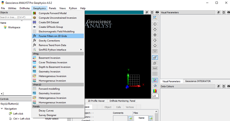
Description
Geoscience ANALYST Pro Geophysics 4.0.2: Advanced Geophysical Interpretation Software for Smarter Exploration
Geoscience ANALYST Pro Geophysics is a powerful geoscience interpretation platform designed for professionals who need to process, visualize, and analyze complex geophysical datasets. Whether you’re working in mineral exploration, environmental studies, groundwater investigations, or energy projects, this software provides an efficient environment for integrating multiple data sources into one comprehensive workspace.
Unlike basic mapping applications, Geoscience ANALYST Pro Geophysics combines advanced 2D and 3D visualization, geophysical inversion support, geological modeling, and data interpretation tools into a single platform. This makes it an excellent choice for geologists, geophysicists, mining companies, consultants, research organizations, and engineering professionals seeking accurate decision-making based on high-quality subsurface analysis.
If your work depends on interpreting magnetic, gravity, electromagnetic, seismic, or resistivity datasets, Geoscience ANALYST Pro Geophysics offers the flexibility and precision required for modern exploration projects.
Introduction
Modern exploration projects generate enormous amounts of geophysical information. Managing these datasets while extracting meaningful geological insights can be challenging without specialized software.
Geoscience ANALYST Pro Geophysics addresses this challenge by offering a professional interpretation environment where users can combine geological models, drillhole information, GIS data, geophysical surveys, topography, and satellite imagery into one unified workspace.
The software is widely appreciated for its interactive visualization capabilities and ability to transform raw geophysical information into practical exploration knowledge. Instead of switching between multiple applications, professionals can complete much of their interpretation workflow inside a single platform.
Its user-friendly interface makes advanced analysis accessible while still providing the sophisticated capabilities expected by experienced geophysicists.
Key Features of Geoscience ANALYST Pro Geophysics
Advanced 3D Visualization
One of the software’s strongest features is its impressive 3D visualization engine.
Users can display:
- Geological surfaces
- Drillhole data
- Geophysical grids
- Topographic models
- Point clouds
- Cross sections
- Voxel models
- Structural interpretations
Interactive rendering allows users to rotate, zoom, and inspect geological structures from every angle.
Multi-Dataset Integration
Exploration rarely depends on a single dataset.
Geoscience ANALYST Pro Geophysics supports the integration of:
- Magnetic surveys
- Gravity data
- Electromagnetic (EM) surveys
- Induced Polarization (IP)
- Resistivity data
- Seismic information
- Geochemical samples
- Geological mapping
- Borehole information
- Digital terrain models
This integrated workflow significantly improves interpretation accuracy.
Geophysical Data Processing
The software includes tools for preparing geophysical datasets before interpretation.
Common processing capabilities include:
- Data filtering
- Grid generation
- Interpolation
- Signal enhancement
- Data corrections
- Quality control
- Survey visualization
Clean datasets often lead to more reliable exploration results.
Interactive Cross Sections
Users can instantly generate cross sections through geological models.
These sections allow professionals to examine:
- Ore body geometry
- Fault systems
- Geological contacts
- Drill intersections
- Geophysical anomalies
Cross-sectional analysis often reveals features that remain hidden in plan view.
Geological Modeling
Geoscience ANALYST Pro Geophysics allows users to create and refine geological models based on integrated datasets.
These models support:
- Mineral targeting
- Structural interpretation
- Resource evaluation
- Geological mapping
- Exploration planning
Model updates remain dynamic as additional data becomes available.
Drillhole Visualization
Drillhole management becomes much easier through comprehensive visualization tools.
Users can display:
- Lithology
- Assays
- Downhole geophysics
- Structural measurements
- Core logging
- Sample intervals
Color coding and attribute filtering simplify data interpretation.
Large Dataset Performance
Exploration companies often manage millions of data points.
Geoscience ANALYST Pro Geophysics is designed to efficiently handle:
- Large geophysical grids
- Extensive drilling campaigns
- Massive point clouds
- Complex geological models
Performance remains responsive even with demanding projects.
Practical Use Cases
Mineral Exploration
Mining companies rely heavily on geophysical interpretation to identify potential mineral deposits.
The software helps exploration teams:
- Identify magnetic anomalies
- Interpret alteration zones
- Map geological structures
- Prioritize drilling targets
- Reduce exploration uncertainty
This can significantly improve exploration success rates.
Groundwater Investigations
Hydrogeologists use geophysical surveys to understand subsurface conditions.
Geoscience ANALYST Pro Geophysics assists with:
- Aquifer mapping
- Bedrock depth estimation
- Groundwater modeling
- Fracture identification
- Water resource planning
The integrated visualization improves confidence in hydrogeological interpretations.
Environmental Site Assessments
Environmental consultants frequently use geophysics to investigate contaminated sites.
Applications include:
- Landfill mapping
- Buried object detection
- Contaminant migration studies
- Infrastructure investigations
- Site remediation planning
The software helps visualize complex underground conditions.
Engineering Projects
Before major construction begins, engineers often require subsurface investigations.
Typical engineering applications include:
- Tunnel planning
- Foundation assessment
- Dam investigations
- Road corridor studies
- Infrastructure development
Combining geophysical surveys with geological information improves project planning.
Academic Research
Universities and research institutions benefit from the software’s visualization and analytical capabilities.
Researchers can:
- Study geological formations
- Interpret regional geophysics
- Build educational models
- Analyze historical datasets
- Present scientific findings visually
The software supports both teaching and advanced research.
Real-World User Experience
Imagine a mineral exploration company evaluating a large copper prospect.
The team has collected:
- Airborne magnetic surveys
- Gravity data
- Hundreds of drillholes
- Geological mapping
- Geochemical samples
- Digital elevation models
Without integrated software, these datasets remain scattered across multiple programs.
Using Geoscience ANALYST Pro Geophysics, the exploration team combines everything into a single 3D project.
As they rotate the geological model, they discover that several magnetic anomalies align with structural faults and favorable lithological contacts. Cross-sectional views reveal additional drilling opportunities that were previously overlooked.
This integrated workflow allows the company to make more informed drilling decisions, potentially reducing exploration costs while increasing the chances of discovery.
Performance Analysis
Performance is one of the software’s strongest characteristics.
Speed
Data loading remains efficient even with extensive geophysical datasets.
Interactive navigation feels smooth during most interpretation tasks.
Visualization Quality
Rendering quality is excellent.
Complex geological relationships become much easier to understand through high-quality 3D graphics.
Accuracy
The software provides reliable visualization and interpretation tools suitable for professional geoscience projects.
Integrated datasets improve confidence during exploration planning.
Workflow Efficiency
Instead of switching between several applications, users complete much of their workflow within one environment.
Benefits include:
- Reduced processing time
- Better collaboration
- Improved project organization
- Faster interpretation
Learning Curve
Although advanced functionality requires some training, the interface remains logical and well organized.
Users familiar with geological or geophysical software generally adapt quickly.
Pros and Cons
Pros
- Excellent 3D visualization capabilities
- Comprehensive geophysical interpretation tools
- Supports multiple geophysical survey types
- Strong geological modeling features
- Handles large exploration datasets efficiently
- Interactive cross sections and drillhole visualization
- Suitable for mining, environmental, engineering, and research projects
- Streamlined workflow through integrated data management
- Professional-grade analytical capabilities
- Reliable performance for complex exploration projects
Cons
- Advanced features may require user training
- High-end projects benefit from modern hardware
- Some specialized workflows may require additional geoscience expertise
- Licensing costs may be significant for smaller organizations
Pricing & Plans
Geoscience ANALYST Pro Geophysics is generally offered as a commercial professional software solution.
Pricing may vary depending on:
- License type
- Professional edition
- Enterprise deployment
- Maintenance agreements
- Optional modules
- Organizational requirements
Prospective users should evaluate available licensing options based on project size, team requirements, and long-term workflow needs.
Why Professionals Choose Geoscience ANALYST Pro Geophysics
Professionals continue choosing this software because it combines powerful visualization with practical interpretation tools.
Some major advantages include:
- Unified geological and geophysical workspace
- Efficient management of complex exploration data
- Advanced 3D geological interpretation
- Improved exploration decision-making
- Better communication between multidisciplinary teams
- High-quality visualization for presentations and reporting
- Scalable performance for projects of varying sizes
These strengths make it a trusted solution across many sectors of the geoscience industry.
Geoscience ANALYST Pro Geophysics Developer
Geoscience ANALYST Pro Geophysics 4.0.2
Final Verdict
Geoscience ANALYST Pro Geophysics stands out as a comprehensive solution for professionals working with complex geological and geophysical datasets. Its ability to integrate multiple data sources, generate high-quality 3D visualizations, and support advanced interpretation workflows makes it a valuable asset for mineral exploration, environmental investigations, engineering studies, and academic research.
While the software offers a rich set of advanced features that may require some learning, the investment pays off through improved workflow efficiency, clearer subsurface insights, and more informed project decisions. Its scalability, reliability, and professional-grade analytical tools make it suitable for both small exploration teams and large organizations managing extensive datasets.
If you’re looking for an advanced geophysical interpretation platform that combines visualization, geological modeling, and data integration in one powerful environment, Geoscience ANALYST Pro Geophysics is well worth exploring. Whether your goal is identifying mineral targets, evaluating subsurface conditions, or improving geological understanding, this software provides the tools needed to turn complex geophysical data into confident, data-driven decisions.




Reviews
There are no reviews yet.