Description
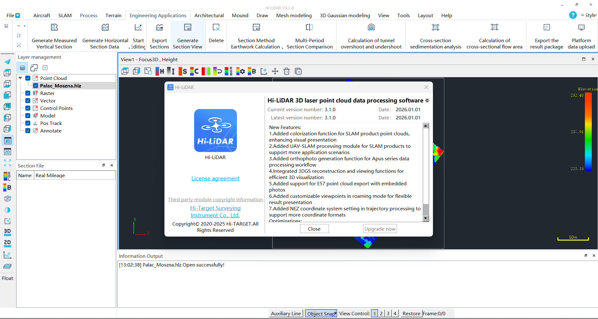
Hi-LiDAR 3.1.0: A Practical Look at LiDAR Data Processing, Point Cloud Analysis, and 3D Mapping
For professionals working with LiDAR data, the right software can make the difference between a complicated point cloud workflow and a smooth, productive mapping process. Hi-LiDAR is designed for users who need to work with LiDAR data, point clouds, terrain information, and 3D spatial datasets in a more efficient and structured way. Whether you are involved in surveying, forestry, infrastructure planning, environmental analysis, or geospatial mapping, LiDAR software can significantly reduce manual work and improve the quality of project results.
In this Hi-LiDAR review, we explore its core capabilities, practical applications, performance, advantages, limitations, and overall value for professionals and organizations working with LiDAR technology. The software is particularly relevant for users who want to process large amounts of laser-scanned data and turn raw measurements into useful digital information.
Introduction
LiDAR technology has transformed the way professionals collect and analyze information about the physical world. From aerial surveys and drone mapping to terrestrial laser scanning and mobile mapping systems, LiDAR produces highly detailed point cloud datasets that can represent terrain, buildings, vegetation, roads, and other physical features.
However, collecting LiDAR data is only the beginning. The real challenge often starts when users need to process, inspect, classify, analyze, and interpret millions or even billions of individual points.
This is where specialized software such as Hi-LiDAR becomes important.
Instead of treating LiDAR data as a simple collection of points, a dedicated LiDAR processing environment helps users organize complex datasets and extract meaningful information from them. For a surveyor, this could mean identifying ground surfaces. For a forestry professional, it may involve analyzing vegetation structure. For an engineering team, the same data might support terrain modeling or infrastructure planning.
The value of Hi-LiDAR depends heavily on the specific workflow, dataset size, and professional requirements. Nevertheless, its focus on LiDAR-based data management and analysis makes it a useful solution for users working in demanding geospatial environments.
What Is Hi-LiDAR?
Hi-LiDAR is a specialized software solution focused on working with LiDAR and point cloud data. Its purpose is to help users handle laser scanning information more effectively, from data preparation and visualization to analysis and extraction of useful spatial information.
LiDAR datasets can be extremely detailed, but they are also complex. A single survey may contain millions of points with information such as:
- X, Y, and Z coordinates
- Elevation values
- Intensity information
- Classification data
- Return information
- Color or RGB values
- Additional metadata
A capable LiDAR software solution helps transform this raw information into practical outputs such as terrain models, elevation analysis, 3D visualizations, and structured survey information.
For users working with point cloud processing, airborne LiDAR, terrestrial laser scanning, or 3D geospatial data, Hi-LiDAR can provide a more specialized working environment than general-purpose design software.
Key Features of Hi-LiDAR
1. LiDAR Point Cloud Processing
At the center of the Hi-LiDAR workflow is point cloud processing. Users working with large datasets need tools that can handle detailed spatial information without making every operation unnecessarily complicated.
A typical LiDAR processing workflow may involve:
- Importing raw or processed LiDAR data
- Inspecting point distribution
- Filtering unnecessary data
- Reviewing elevation information
- Organizing point cloud datasets
- Preparing data for further analysis
This can be especially valuable for projects where manual point-by-point inspection would be too slow.
2. 3D Visualization
Three-dimensional visualization is one of the most useful capabilities in any LiDAR workflow.
Instead of viewing a dataset as a flat collection of coordinates, users can inspect the landscape or scanned environment in a more intuitive way. This helps professionals understand:
- Terrain shape
- Buildings and structures
- Vegetation height
- Road corridors
- Slopes and elevation changes
- Surface irregularities
For someone reviewing a large survey, the ability to visually inspect data can make it easier to identify potential problems before they affect the final deliverable.
3. Terrain and Elevation Analysis
Elevation data is one of the primary reasons organizations use LiDAR. Hi-LiDAR can be useful in workflows where users need to understand variations in terrain and surface levels.
Potential analysis areas include:
- Digital terrain modeling
- Elevation comparison
- Slope evaluation
- Contour generation
- Surface interpretation
- Topographic analysis
For civil engineering and land development projects, this type of information can support early planning and design decisions.
4. Data Classification and Filtering
Large point clouds often contain different types of information mixed together. Ground points, buildings, trees, power lines, vehicles, and other objects may all exist within the same dataset.
Classification and filtering tools can help users separate data into more meaningful groups.
For example, a survey team may want to isolate:
- Bare earth
- Buildings
- Vegetation
- Roads
- Water surfaces
- Man-made structures
This improves the efficiency of later processing and can help users create more accurate models.
5. Support for Professional Geospatial Workflows
LiDAR rarely exists in isolation. In many professional projects, point cloud data is combined with GIS, CAD, surveying, photogrammetry, and engineering information.
A practical LiDAR solution should therefore fit into a broader workflow rather than forcing users to work in a completely separate environment.
This makes Hi-LiDAR relevant to professionals who need to move from raw laser scanning data toward useful mapping, modeling, and engineering outputs.
Practical Use Cases for Hi-LiDAR
Surveying and Mapping
Surveying professionals frequently work with large datasets collected by drones, aircraft, mobile scanners, or terrestrial LiDAR equipment.
A typical workflow might look like this:
A survey team collects detailed LiDAR data over a construction site. The raw dataset contains millions of points, but the project manager needs accurate terrain information. Using a LiDAR processing workflow, the team can inspect the data, identify ground points, analyze elevation, and prepare information for further design work.
This can save considerable time compared with traditional manual measurement methods.
Civil Engineering and Infrastructure
Roads, bridges, railways, utility corridors, and other infrastructure projects often require accurate information about terrain and existing conditions.
LiDAR data can help engineering teams evaluate:
- Existing ground conditions
- Road corridors
- Embankments
- Cut-and-fill areas
- Drainage patterns
- Structural surroundings
For infrastructure planning, detailed 3D spatial data can provide a stronger foundation for design decisions.
Forestry and Environmental Analysis
LiDAR is also widely used in environmental and forestry applications.
A forest dataset can contain information about tree height, canopy structure, terrain, and vegetation density. By processing this information, professionals can better understand the physical characteristics of a landscape.
Potential applications include:
- Forest inventory
- Canopy analysis
- Habitat studies
- Vegetation monitoring
- Terrain assessment
- Environmental planning
For researchers and environmental professionals, LiDAR provides a powerful way to study large areas without relying entirely on traditional ground surveys.
Construction and Site Monitoring
Construction companies increasingly use 3D scanning and LiDAR to monitor project progress.
A project team may capture site data at different stages and compare the results over time. This can help identify:
- Construction progress
- Changes in terrain
- Material volumes
- Site conditions
- Potential deviations from planned designs
The ability to work with detailed spatial information can improve communication between field teams, engineers, and project managers.
Mining and Earthworks
Mining and earthworks projects often depend on accurate measurements of terrain and material volumes.
LiDAR processing can support workflows involving:
- Stockpile measurement
- Terrain modeling
- Excavation monitoring
- Volume calculations
- Site surveying
For companies working across large or difficult-to-access areas, LiDAR can provide a faster way to collect detailed spatial information.
Performance Analysis
The performance of any LiDAR software depends on several factors, including dataset size, hardware configuration, storage speed, graphics capabilities, and the complexity of the workflow.
Hi-LiDAR is most valuable when users are working with datasets that would be difficult to manage through basic mapping or design tools.
Data Handling
Large point clouds can place significant demands on a computer system. Efficient data management is therefore essential. Users working with high-density LiDAR scans should pay close attention to:
- Available RAM
- Processor performance
- GPU capabilities
- SSD storage
- Dataset organization
When the hardware is properly configured, a specialized LiDAR environment can make the process of inspecting and analyzing complex data much more practical.
Workflow Efficiency
One of the main benefits of dedicated Hi LiDAR software is workflow efficiency.
Instead of switching repeatedly between unrelated tools, users can often perform several stages of the data review and analysis process within a more focused environment.
This is particularly helpful for professionals who process LiDAR data regularly and need a repeatable workflow.
Accuracy and Professional Results
LiDAR projects are often used for engineering, surveying, planning, and scientific analysis. Accuracy is therefore a major consideration.
The quality of the final result depends not only on the software but also on:
- The original LiDAR sensor
- Survey methodology
- Georeferencing
- Point density
- Classification quality
- Data cleaning
- User expertise
Hi-LiDAR can support professional workflows, but users should always validate important measurements and outputs according to their project standards.
User Experience and Learning Curve
For new users, LiDAR software can initially feel complex. Point clouds contain much more information than ordinary 2D drawings, and the terminology can take time to understand.
A beginner may need to learn concepts such as:
- Point cloud density
- Classification
- Ground filtering
- Digital elevation models
- Returns
- Coordinate systems
- LiDAR accuracy
The good news is that users who work with LiDAR regularly often find that specialized software becomes easier to understand over time.
For experienced surveyors, GIS professionals, and engineers, the workflow may feel more natural because the software is built around the type of data they already use.
A practical approach is to begin with smaller datasets, learn the visualization and filtering tools, and gradually move toward more advanced analysis.
Pros and Cons of Hi-LiDAR
Pros
- Designed specifically for LiDAR and point cloud workflows
- Useful for handling detailed 3D spatial datasets
- Supports terrain and elevation analysis
- Helpful for surveying, engineering, forestry, and mapping applications
- Can improve productivity compared with manual data inspection
- Useful for visualizing complex environments in 3D
- Supports professional geospatial data workflows
Cons
- May require time for beginners to learn
- Large datasets can demand powerful computer hardware
- Advanced LiDAR processing workflows may require technical knowledge
- The overall value depends on project requirements and available data formats
- Users may need additional software for certain specialized outputs
Pricing and Plans
The pricing structure for HiLiDAR may vary depending on the edition, licensing model, professional requirements, and available distribution options.
Potential factors that can affect the total cost include:
- Individual or commercial licensing
- Number of users
- Maintenance or update options
- Professional modules
- Enterprise requirements
- Support services
For businesses, the most important consideration is not simply the purchase price. Productivity improvements, reduced manual processing, and better project turnaround can have a significant impact on the overall return on investment.
Before choosing a licensing option, organizations should evaluate the size of their LiDAR datasets, the number of users, and the specific processing features required for their projects.
Who Should Use Hi-LiDAR?
Hi-LiDAR may be a strong choice for:
- Land surveyors
- GIS professionals
- Civil engineers
- Mapping specialists
- Forestry professionals
- Environmental researchers
- Construction companies
- Mining and earthworks teams
- Drone mapping operators
- Organizations working with 3D point clouds
It may be less suitable for users who only need occasional basic 3D visualization and do not regularly work with LiDAR datasets.
Final Verdict
Hi-LiDAR is a specialized solution for professionals who need to work with LiDAR data, point clouds, terrain information, and 3D spatial analysis. Its greatest value comes from helping users move beyond raw laser-scanning data and toward information that can support real-world decisions.
For surveyors, engineers, mapping specialists, environmental professionals, and other users working with large geospatial datasets, a focused LiDAR workflow can improve productivity and make complex information easier to understand.
The software is not necessarily aimed at casual users. Like most professional LiDAR tools, it may require some learning and a capable computer system for large datasets. However, users who regularly process point clouds can benefit from having a dedicated environment designed around the challenges of LiDAR data.
If your work involves aerial scanning, terrestrial laser scanning, terrain analysis, 3D mapping, or point cloud processing, Hi-LiDAR is worth exploring as part of your professional workflow. The best way to evaluate its value is to test it against your own datasets and determine how effectively it supports the tasks that consume the most time in your current process.

Reviews
There are no reviews yet.